Thứ Ba, 14 tháng 12, 2010

A World Class Museum in the Middle of Nowhere


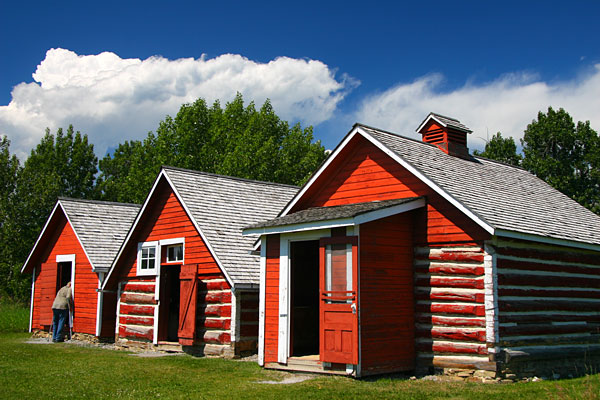
A 90-minute drive northeast of Calgary, between the prairies and even more prairies, lies a medium-sized town that one of my coworkers call, in a humorous and slightly condescending way, "Dino Village."


Now that's not all condescending -- even the town's own official website is currently titled "Town of Drumheller - Dinosaur Valley," so there's a bit of truth in the humor. The town is actually one of the booming natural gas producing areas in its own right, though to virtually every visitor the main reason for the detour has to do with the region's rich fossil deposits, culminating inside a huge, well-organized and truly world class museum -- the Royal Tyrrell Museum of Paleontology.


Anyone who has ever taken a multi-day roadtrip anywhere in North America has the right to be skeptical of the word "museum" -- thousands of roadside "museums" exist for the purpose of showcasing anything from an old granny's collection of sewing machines to the amazing world of perogies. But Royal Tyrrell is one of the best in Canada, hosting 10 million visitors in its 25 year existence and granted royal status by the Queen. That's quite an accomplishment considering its location in a relatively remote region in southern Alberta, nowhere close to the main highway connecting Calgary and Edmonton. Visitors don't come this far unless there's a real good reason.


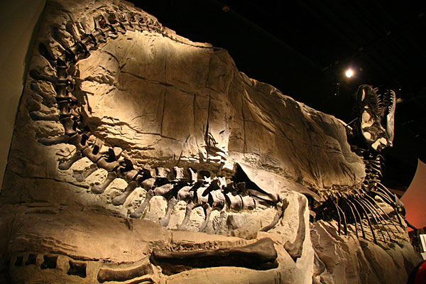
But why on earth would the government of Alberta invest in a world class museum in the middle of nowhere, as opposed to Calgary or Edmonton? Well here's the uniqueness of Royal Tyrrell -- the museum is situated right in the middle of one of the prime fossil-producing areas in North America, and some of the fossil displays were excavated within short distance of the museum. That includes the famous Albertosaurus, a smaller, but equally terrifying, Canadian version of the T-Rex.


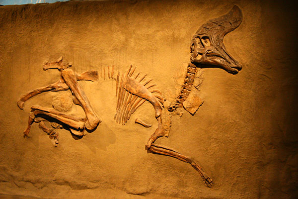
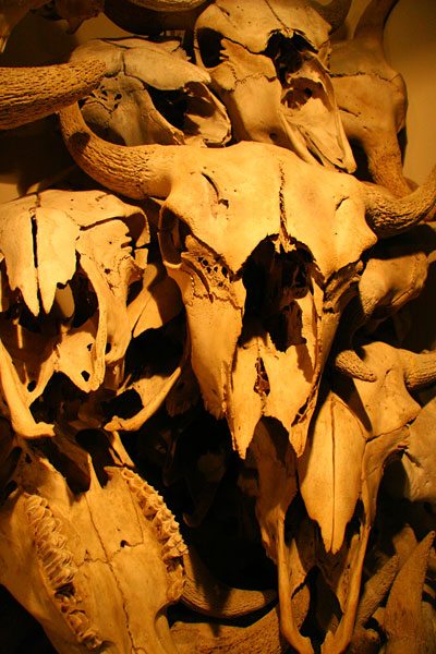
Almost all exhibits were excavated from within Western Canada, with many coming from local sites in southern Alberta. Hadrosaur skeletons like the one pictured here can be found in the vicinity of Drumheller, while a near-complete nesting site had been found further south in Devil's Coulee.


Walking into any jewelry shop in Alberta and you'll find a uniquely Albertan gemstone with a wildly colorful, iridescent opal-like appearance. One of the rarest gemstones on earth, Ammolites (with an L) are organic gemstones made of fossilized shells of ammonites (with an N), a now-extinct group of molluscs that roamed the Alberta seas in the Mesozoic Era. If a fingernail-sized piece on a pendant costs upwards of CAD$500 (see Korite.com) in local jewelry shops, this 3-foot-diameter shell here must be near priceless.


Aside from serving as an interpretive museum to the public and raising public awareness to Alberta's rich fossil records, Royal Tyrrell is renowned in the academic world as a premier research centre for paleontology, complete with an excellent backyard for fieldwork. The Horseshoe Canyon, just a few kilometers to the west of the museum, contains some of the most abundant Mesozoic fossil beds in Canada.


Fossils excavated from the field are transported back to the lab for preparation and cleaning. To provide visitors with a real-life demonstration of the daily work in a paleontology lab, one of the museum's resident technicians set up a curator station with a working sample to explain the whole process of removing the surrounding rock to expose the fossil.


But what really sets this museum apart from most fossil exhibitions I've visited is its focus on interpretation and public education. For visitors staying for more than a couple hours, the museum provides a wide variety of hands-on learning programs ranging from fossil casting for kids to guided hikes to a nearby dinosaur quarry. We ran out of time, but I seriously considered joining an excavation clinic where participants learn to extract replica dinosaur bones in a simulated quarry environment.


Taking public education a step further, the museum even offers accredited paleontology courses within the local school district for high school students working towards their graduation. That's miles ahead of typical museums focusing on academic research and exhibition.


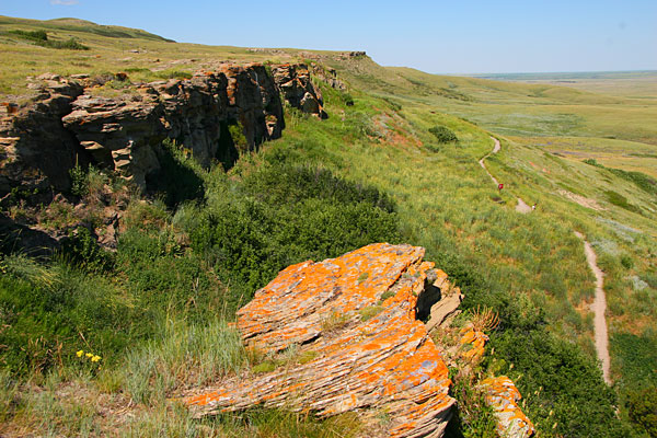
Well, even a world class museum is still a museum. The best way to really appreciate Southern Alberta's natural heritage is to walk among the outlandish rock formations of the badlands. Just outside the museum is a short, well-marked interpretive trail taking visitors through the moonscape-like layers of fossil-yielding sedimentary rocks. One word of advice though ... come back an hour before sunset for the most dramatic colors and contrasts. The above picture was taken around noon and does not do any justice to the beauty of badlands scenery at sunset. Just compare the above picture with those taken at Dinosaur Provincial Park at sunset in the next post and you'll be convinced.

Thứ Hai, 13 tháng 12, 2010

Our 2,000 km Drive across the Alberta Prairies


A lazy summer road trip is one of those luxuries rarely allowed for people like myself, one of millions of slaving city folks drowning in daily work in Canada. So when we decided upon a Canadian Rockies trip this past summer, we slowed down to let our eyes, and my camera shutter, fully appreciate a very Canadian landscape that I never had the chance to experience -- the great vastness of the Alberta Prairies.


Oil pumpjacks are undoubtedly one of the integral images coming of Alberta's landscape, but that's gradually changing with biodiesel-producing canola fields spreading across the prairies, and giant wind turbines popping up along the foothills in southern Alberta.


Old-fashioned working ranches still dominate much of the landscape in southwestern Alberta, which remains the centre of the province's beef cattle industry today. A succulent cut of prime rib from Alberta's Black Angus beef is one of my own favorite Canadian dishes.


Another ubiquitous sight during Albertan summers, these gigantic rolls of hay bales typically weight several hundred kilograms each. To many visitors few images better evoke the allure of rural life than an endless ocean of golden hay bales basking under the sun, but here in Canada once in a while we do hear about people being seriously injured or killed by the crushing weight of these bales when not handled properly.


Among the joys of road-tripping are the unexpected discoveries outside of the original itinerary. Due to my own ignorance I had never heard of Fort Macleod prior to stumbling into this movie-set of a town. Situated at the convergence of ancient Blackfoot Indian encampments and the wagon trails of the Canadian Old West, Fort Macleod was once one of the important settlements in southern Alberta back in the 1910's.


Nowadays the historical main street, Colonel Macleod Boulevard, still illustrates the frontier town's former glory through the careful preservation of its sandstone buildings, some dating back to the late 1800's. Built in 1912, the Empress Theatre in the previous picture is Western Canada's oldest continuous operating movie theatre and still features Hollywood's latest flicks on a nightly basis. Pictured here is the now closed Java Shop restaurant, of Brokeback Mountain fame.


"R.G.Mathews Real Estate." The building itself is over a century old, and this Mathews fellow was said to have moved out of the town by 1920. The structure, like most of the old town centre, is protected as a Provincial Historic Area to preserve all the architectural details and signages from early 20th century. This was a pleasant discovery both my wife and I thoroughly enjoyed -- the romantic atmosphere for her, and the photogenic scenery for myself.


But our real reason for driving through Fort Macleod was to visit one of Canada's lesser-known UNESCO World Heritage Sites, an ancient Blackfoot hunting ground known as Head-Smashed-In Buffalo Jump. Over these very cliffs hundreds of thousands of American bisons plunged to their deaths, driven by the ingenious strategies and teamwork of the indigenous hunters. A modern interpretive centre provides the background information for inquisitive visitors, but it's seeing the actual cliffs that completes the haunting experience.


Through our 21st century eyes we may call it animal cruelty, but for the previous thousands of years it was simply the reality of survival. This was the ultimate test of wits between man and nature, with grave consequences for the defeated. A botched hunting season could lead to the decimation of a tribe through the long Canadian winter, which provided incentive for entire societies to dedicated their resources to refine the hunting process to an art form. Traps and decoys would be carefully set up, and actors would cover themselves in animal grease and skin to smell, look and move like wolf packs or bison calves in the eyes of the hunted. In today's terms this was a battle plan that combined a nation's expertise on animal behavior, logistics, meteorology, strategic planning, training and execution. Anyone remotely interested in the history of the First Nations People shouldn't miss this place.


After visiting the somber monument of life-and-death in the prehistorical era, a two-hour-drive to the northwest would transport the visitor to a more romantic time of cowboys and Indians, Mounties and outlaws. The Bar U Ranch National Historic Site is the last remnants of a mighty ranching empire that once boasted tens of thousands of cattles and fed much of Western Canada.


The small number of buildings surviving to this day are exhibited as part of an interpretive program, complete with historical furnishings, hands-on demonstrations, and a horse-drawn carriage ride to transport visitors around the site. The syrupy smell of fresh oven baking permeated the cookhouse in this picture, where a talented staff made cookies and pies for our tasting using hand tools and an antique wood-burning oven and stove.


If you have read this far and are intrigued by some of these sights and experiences, I must say that these were only the little side-trips while we visited the real star attractions of southern Alberta -- Waterton National Park, Dinosaur Provincial Park and Drumheller. Those will be shared in the next several posts.

Thứ Sáu, 5 tháng 11, 2010

Banff's Spectacular Sub-Alpine Meadows


After reviewing 1,500 pictures taken in the Canadian Rockies, this emerged as my personal favorite.

Now this place is certainly not world famous like Lake Louise, or a Canadian favorite like Moraine Lake, or possess the eye-catching turquoise blue of Peyto Lake. To me this is a breathtaking location that strikes the right balance between the spectacular beauty that everyone expects of the Canadian Rockies, with the ruggedness and hidden power of nature that can catch anyone by surprise.


Where's this place? It is a sub-alpine plateau of 2,200m elevation, an enchanted kingdom of 360-degree panoramas, summer wildflowers and wildlife, yet easily accessible through a shuttle bus service.

While locals rate it as one of the best hiking grounds near Banff, it seems to have remained under the radar of most visitors. Some tourists are deterred by the lack of public road access, but richly rewarded are those willing to pay for the privilege of arriving at some of the most photogenic alpine scenery anywhere.


This mountain-top is known locally by two names, depending on the time of year. From November through early May, cable gondolas whisk skiers and snowboarders to the Canadian Rockies' largest ski resort known as Sunshine Village. But from mid-June to late September, gondolas give way to a shuttle bus and the mountain transforms into a hiker's wonderland known as Sunshine Meadows.


10 metres of annual snowfall melts away in the early summer, revealing a well-maintained network of trails and footpaths that wind past lush green meadows and emerald-colored lakes. Hiking season is short and dramatic, beginning with residual snow in June, an explosion of wildflowers in July and August, and the brilliance of Autumn foliage in September.


There are two ways of getting to Sunshine Meadows -- either hike uphill for 2 hours from the base of the winter gondola, or take a 15 minute shuttle bus ride. Regular price for the shuttle bus is $26, but at the time of writing you can apply for a free Travel Alberta Card prior to your trip and get a 15% discount by simply flashing your card.


Wild creatures large and small inhabit this pristine plateau. Not only is the meadows known to be one of the prime grizzly bear habitats in Banff National Park, the entire mountain seems to be a giant colony of hundreds of thousands of ground squirrels. This one in particular wanted to make friends with my water bottle.


It was also the beginning of wildflower season when we visited in mid-July, with fascinating alpine flowers of every color springing from the snow-irrigated wetlands along the trails. Bright red Indian Paintbrushes and bushy Western Anemones were most prominent during our visit in mid-July.


If you can time your visit in August, Sunshine Meadows organizes a Wildflower Week every year with guided interpretive hikes and photography workshops. Even if you can't, the brilliant hues of alpine lichens and a plethora of wildflowers are there to guide you along the trails all summer.


The main trails range from easy to moderate in difficulty, and a trail map can be downloaded from the official site. We rode the 11:00 bus to the Nature Centre at the top, took the Rock Isle Trail to the Rock Isle Viewpoint for a picnic around noon, hiked up to the Standish Viewpoint after lunch, then looped around the lakes on the Garden Path Trail before returning to the Nature Centre in time for the 16:30 bus down the mountain.

This easy 10km hike was certainly our most memorable in the Canadian Rockies, though the more adventurous may prefer to use Sunshine Meadows as a launching point for serious hikes along the Continental Divide. Regardless of your fitness level, just remember to bring your camera -- it's just impossible not to come home with satisfying pictures.

Chủ Nhật, 3 tháng 10, 2010

Photo Sequence of a World Famous Road - Canada's Icefields Parkway


This is a photo sequence of one of the world's most scenic roads, a heavenly 230km along the continental divide of North America, passing majestic glaciers, brilliant turquoise lakes, and sweeping valleys cutting between the wild jagged peaks of the Canadian Rockies. If I have only one day to bring an friend from overseas to see the best of Canada, this would be my pick.

And it's not only my pick -- National Geographic has it listed among the 50 best drives in the world, as well as the Top 10 ski trips in the world; Lonely Planet ranks it among the world's top 10 cycling trips; UNESCO protects the entire surrounding area as a World Heritage Site. Welcome to Icefields Parkway.


0km from Jasper
Our journey started from the Jasper Townsite. Pictured is the Jasper Information Centre, one of the finest pieces of rustic Canadian architecture and a National Historic Site in itself. Constructed of cobblestones and timber nearly 100 years ago, the relatively small structure originally housed a plethora of park functions, including a fish hatchery in the basement. Most visitors no longer arrive at the rail station across the street, but the old building still serves as the town's most recognizable landmark.


31km from Jasper
The Athabasca Falls is the first of several major waterfalls and canyons along Icefields Parkway. Glacial water originating from the Columbia Icefield carves a narrow canyon through the soft limestone here to continue its way towards the Arctic Ocean.


Dramatic flowing lines were once scribed on these limestone walls by the mighty Athabasca River, which has since carved out a new channel underneath. A well-maintained trail now leads visitors through these passages, ending at the other side of the rocks with a sweeping view of the river valley.


55km from Jasper
A 15 minute drive to the south, the turbulent waters of the spectacular Sunwapta Falls plunges down another chasm and will eventually join the Athabasca River. Just below these waterfalls is the launch point of a Class 3 white water rafting course, a 2-hour journey costing less than CAD$100.


100km from Jasper
At the legal speed limit of 90km/h the entire drive from Jasper to Banff can theoretically be covered in less than four hours. It took us no less than eight -- and it was eight hours of breathtaking scenery and short hikes launching directly from the roadside. Pictured is a view of North America's continental divide from a roadside pullover with no name.


103km from Jasper
The 300-plus-metres-thick Columbia Icefield marks the boundary between Banff National Park and Jasper National Park. Directly accessible from the side of the highway is the Athabasca Glacier, one of the six toes of the icefield and the most visited glacier in North America. If you've come this far to the Canadian Rockies, don't miss the chance to set foot on the ice pack. Please see our Athabasca Glacier page for a quick glimpse of what you may see on a guided hike up the glacier.


160km from Jasper
A 40 minute drive into Banff National Park leads to yet another spectacular valley. The Mistaya River carves a winding path through stratified layers of limestone and creates a narrow slot canyon on its way towards Edmonton, and eventually the Hudson Bay.


175km from Jasper
At about 100km north of Banff the Icefields Parkway starts entering the heart of lake country. The pictured Lower Waterfowl Lake is just one of hundreds of lakes in the region, all endowed with the brilliant turquoise waters that made the Canadian Rockies famous.


182km from Jasper
This well-signposted trail starting from the roadside is one of the most popular short hikes in Canada -- which leads to one of the best viewpoints in Canada. We had to contend with hordes of multi-national tourists on the 20-minute hike, but the view, 300-metres above the brilliant Peyto Lake and its magical surroundings, alone makes visiting the Rockies worthwhile.


Aside from boasting one of the most breathtaking views in the Canadian Rockies, this viewpoint area, known as Bow Summit, is also famous as the highest point along the Icefields Parkway at 2,069m. Time your visit in July to September if possible, as the best and brightest colours are typically brought out by when summer's glacial melting peaks.


192km from Jasper
Yet another brilliant turquoise lake alongside the highway, Bow Lake is the source of the Bow River that flows through Banff and Calgary. This trademark opaqueness of blue and green is caused by what the local guides call "glacial rock flour," a suspension of microscopic clay particles filtering out part of the blue from the visible light spectrum.


232km from Jasper
At the southern end of the Icefields Parkway, the world famous Lake Louise and the classy Fairmont Chateau beckons with its well manicured garden and the unbeatable view of the Victoria Glacier across the lake. In better weather we would have loved a romantic excursion on the emerald-coloured lake in one of these bright red canoes, rentable for about CAD$45 per hour. Hiking up to the Lake Agnes Teahouse is also a popular option in good weather, but on this day we opted for the leisurely Lakeshore Trail.


248km from Jasper
A 16km turn-off from Lake Louise village leads to an unbelievably blue lake, mysteriously opaque and bright and gracefully set beneath a series of majestic peaks. The view of Moraine Lake and the Valley of the Ten Peaks is one of the most-photographed locations in all of Canada, with obvious reasons -- the lake really is as blue as pictured above, and it is well-known locally as the image on older $20 banknotes. Do not expect a serene mountain surrounding when taking your obligatory photo though, as we had to hike past hundreds of tourists to the top of the rockpile for this shot.


260km from Jasper
Although the "Icefields Parkway" designation officially ends at Lake Louise, the highway keeps pointing southeast for another 56km before finally reaching Banff. Visitors have a choice of 2 roads -- the newer, faster throughfare of Highway 1, or the old, winding and more scenic Highway 1A, also known as the Bow Valley Parkway. The Bow Valley Parkway is supposed to be one of the prime wildlife-viewing areas in the Canadian Rockies, but we saw nothing bigger than squirrels along this road. The best wildlife-viewing area on our trip IMHO was Maligne Lake Road in Jasper National Park.


288km from Jasper
Banff, the mother of all Canadian resorts, awaited at the finish of our 8-hour-drive through the magnificent mountain scenery above. This would serve as our homebase for exploring the surrounding area for the next three days.


What better way to celebrate a great alpine drive than warming our hands around a bubbling cheese fondue in Old World tradition? Fairmont Banff Springs hotel's German restaurant, the Waldhaus, featured an excellent Gruyere fondue with generous shavings of black truffles for CAD$56 for a two-person serving. The pungent flavors of truffles was heavenly to my tastebuds, though my wife found it to be somewhat overpowering. This was one of the three best meals on our 15-day trip.

Thứ Bảy, 2 tháng 10, 2010

Up Close and Personal with Athabasca Glacier


This may be the closest to an Antarctic landscape that one can visit and photograph, without actually going to Antarctica.

It has so many elements befitting the most exotic of expeditions. Crystal clear glacial water carving deep blue streaks through a barren, lifeless world. Incredible blue caves born within virgin ice deposits untouched for millenia. Bottomless crevasses waiting to devour the inexperienced (or unequipped). The only things missing are a few penguins, or perhaps an old Roald Amundsen camp.

But no, it's only the Canadian Rockies ... no more than a couple kilometres from the highway in fact.


The Athabasca Glacier is one of the major attractions of the Jasper National Park, and is one of the most accessible glaciers in the world. It's so easily accessible that a visitor centre has been built across from it, next to the highway connecting Banff and Jasper.

Half a million visitors every year would admire the glacier from the comfort of the visitor centre's viewing deck, several hundred metres away. Those who desire to see it up close would typically board a giant Snowcoach to a mechanically flattened, carefully manicured parking area in the middle of the icefield. This makes the icefield safe, sterilized and accessible to virtually anyone, but it also shields the visitor from the natural ruggedness of the ice formation, the chutes and crevasses, and the icy blue creeks.


The raw beauty of the glacier is normally reserved for experienced mountaineers -- numerous deaths have resulted from unsuspecting visitors falling into crevasses and sinkholes, and Parks Canada discourages going across the safety barriers at all. For inactive 9-to-5 office people like myself, the only (relatively) safe way is to join an ice walking tour led by experienced guides.


We joined a small-group tour organized by Athabasca Glacier Icewalks, taking us up the lower third of the glacier on a 3-hour hike. We booked two months ahead online, but the tour is also bookable at the visitor centre if spaces remain available. More than 20 people showed up when we visited in mid July, and the group was split between two guides to keep group sizes manageable and participants safe.


Arriving at the height of summer (both Vancouver and Calgary hit 30 degrees Celsius that week) we greatly under-estimated the bone-chilling cold of the Rockies, even in July. I showed up in a flimsy windbreaker, jeans, light walking shoes, and my wife wasn't any better equipped. Luckily all necessary clothing and equipment were provided by our guides, including 3-in-1 waterproof jackets, waterproof pants, waterproof hiking boots of various sizes, fleece toques and gloves, but most importantly, crampons to provide traction on the ice surface.


The 300 metres or so of elevation that we gained in our 3 hour hike was much slower than I anticipated, not because of any extraordinary physical demands or steepness of grade, but because of the slipperiness of the surface. As we zigzagged our way up the glacier, every step was taken with the apprehensiveness of treading through an enormous uphill skating rink with winding creeks and bottomless abysses.


The 6km long Athabasca is only one of the many glaciers flowing out from the 300km2 Columbia Icefield, situated on top of the continental divide of the North American continent. The icefield is claimed to be one of the hydrological apexes of the North American continent, meaning that ... and I did NOT personally attempt this ... if you take a piss at the top of the icefield, your fluid would possibly split and drain into the Pacific Ocean, the Arctic Ocean, and the Hudson Bay.


At the midpoint of our hike we came across one of the metal poles pounded vertically into the ice sheet by scientists to measure the movement and health of the glacier. At the beginning of the tour we learned that the glacier had already retreated 1.5km over the past century, but it was only a trivial piece of statistics ... until we witnessed the evidence first hand. A thickness of 3 metres had already melted between April and our visit in July, and even more would dissipate before the start of winter.


That's the cold reality facing every visitor in this age of global warming. The Athabasca Glacier is currently retreating at a rate of 10 metres per year and accelerating. Some alarmists even go as far as predicting its complete disappearance within the next century, though not every scientist agrees. The only thing we know for certain is that by the time of our next visit, whether it will be next year or after several decades, the mighty glacier will be a smaller remnant of its current self.


Visiting the Athabasca Glacier was one of those rare, deeply haunting experiences for me as a traveler. Do I absolutely need to take long flights to faraway destinations every year? What will be my own carbon footprint in my lifetime, and how much of that will contribute to glaciation shrinkage in the Rockies, the submersion of the Maldives, or the breakup of the Bering Sea ice packs?

These questions are too heavy for a lazy midsummer roadtrip, yet it pains me as a Canadian that one of our great natural treasures may not even last the entire 21st century. I seriously debated whether I should even promote the Athabasca Glacier as a tourist destination here, but arrived at the conclusion of yes -- if only to heighten each visitor's awareness of his or her own carbon footprint. Perhaps our glacier will breath just a little easier with each carpool trip we take, until we as a human race can find a solution to global warming.